The PRISM Group, founded by Dr. Christopher Daly in 1991, is part of the Northwest Alliance for Computational Science and Engineering (NACSE), which is housed in the College of Engineering at Oregon State University.
PRISM is the qualitative source of current and historical weather data for multiple federal and state agencies, nonprofits, commercial groups, and research institutions.
See the PRISM History document for detailed information about the founding and development of the PRISM model, as well as its uses.
MethodologyThere are many locations in the US for which no weather observations exist. To create a continuous weather map across the country, our automated systems collect weather station observations from tens of thousands of reporting stations per day. These observations are fed into a sophisticated computer model called PRISM (Parameter-elevation Regressions on Independent Slopes Model).
| PRISM estimates variables such as temperature and precipitation for a grid of millions of pixels, each measuring about 0.5 mile (about 800m) across over the entire conterminous US, every day. | 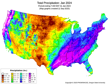 |
High quality station data: Each day, PRISM collects data from over 25,000 precipitation and temperature stations. These include all of NOAA’s major networks; those operated by the US Forest Service, Bureau of Reclamation, and USDA; the large CoCoRaHS precipitation network; state and regional systems operating in many parts of the country; and Environment Canada stations. More networks are being added all the time.
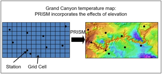 |
For grid cells where no observations exist, PRISM mimics the thinking an expert meteorologist would follow. The model simulates how weather conditions vary with elevation, and accounts for coastal effects, temperature inversions, and terrain barriers that can cause rain shadows. |
Special Projects
Among other things, the PRISM group developed and produced USDA's official Plant Hardiness Zones, the standard by which gardeners and growers can determine which plants are most likely to thrive at a particular location. The data and maps are used by agriculturalists, nurseries, and gardeners throughout the US and have been downloaded millions of times.